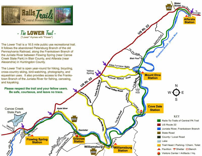
About
The Lower Trail runs for almost 17 miles from near Canoe
Creek State Park in Blair County northeastward to near
Alexandria in Huntingdon County. The trail has a rolled
crushed limestone surface except for a 2 mile asphalt
section through the Borough of Williamsburg and running
northeastward. The trail is extremely flat with only a
slightly noticeable grade when riding from east to west. The
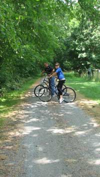
Lower Trail is open year-round for hiking, biking, horseback
riding, bird watching and photography and, in the winter
months, cross country skiing and snowshoeing (any
non-motorized use).
History
Much of the Lower Trail, paralleling the Frankstown Branch
of the Juniata River, was part of the original towpath of
the Pennsylvania Main Line Canal which operated in the mid
1800s. Following the end of the canal era, the Pennsylvania
Railroad took over the property and developed the Petersburg
Branch of the PRR on this alignment. In 1979, the rail
corridor was abandoned. Over the next 8 years, the rails
were sold for scrap and the corridor put up for sale. In
1989, Rails to Trails of Central Pennsylvania Inc. purchased
the first 11 miles of the Lower Trail from Williamsburg to
Alfarata from the Penn Central Corp. Another 5 ½ mile
extension was added in 2004.
The trail's name rhymes with "flower" and honors the
memory of the wife and son of the late trail benefactor,
T. Dean Lower.
Distinctive Features
When traveling along the trail, either by foot or bike,
you can see many remnants of the canal era, including
remains of locks and foundations of lock tenders' houses,
as well as the historical Mt. Etna iron plantation area.
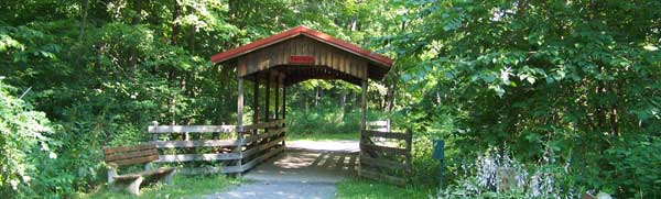
There are a number of bridge crossings of the Juniata
River and one covered bridge over the tail race of a
historic mill stream. Remains of tipples and massive
concrete rock crushers from abandoned stone quarries along
the trail hint of the once industrial nature of the
now-unbroken forest beside the river.
The trail supports many different plant and animal
species and the Audubon Society has identified portions of
the Lower Trail as Important Birding Areas. A number of
Bald Eagles and Osprey have been spotted along the trail.
There are also many beautiful and some rare plant species
along the trail. The Lower Trail is part of the Mid State
Trail and the Pittsburgh-to-Harrisburg Main Line Canal
Greenway and has been designated a National Recreation
Trail by the National Park Service. It is a beautiful,
very family-friendly rural trail through wooded areas with
few road crossings and provides access to the adjacent
Juniata River Water Trail.
- Length: 16.5 miles in length
- Trail surface(s): 85% crushed rolled limestone,
15% paved
- Trailheads: Trailheads are called "Stations"
because when the railroad ran, there were station stops
there.
Directions from US Route 22
- Alfarata Station: Turn North onto Main Street
toward Alfarata between Waterstreet and US Route 22
bridge crossing the Juniata River, proceed approximately
0.2 miles; trailhead is on the right at 1332 Main Street, Porter Township.
- Mt. Etna Station: Turn onto Polecat Hollow
Road, (located halfway between Waterstreet and Route 866
along US Route 22), turn Right off of US Route 22 if
traveling east, turn left off of Route 22 if traveling
west). Travel to the end of Polecat Hollow Rd, then turn
left onto Fox Hollow Road 0.1 mile; trailhead is on the
right at 9093 Fox Run Rd, Williamsburg, PA 16693.
- Covedale Station: Turn east on Yellow Springs
Road, then left on Cross Valley Road, then right onto
Fox Run Road, then left onto Overlook Road to the
trailhead at 419 Overlook Dr, Williamsburg, PA 16693.
- Williamsburg Station: Turn onto Route 866 at
the base of Short Mountain, travel into the town of
Williamsburg. At the first stop sign, proceed straight
for two blocks; trail head is on the left at 11 Juniata St, Williamsburg, PA 16693.
- Grannas Station: Turn east on PA Route 866,
turn right onto Lower Piney Creek Road immediately after
crossing the metal truss bridge, then turn right into
the trailhead at 195 Tinkertown Ln, Williamsburg, PA 16693.
- Flowing Spring Station: Turn southeast onto
Flowing Spring Road. Cross the bridge, then follow the
road back a short distance. A sign will direct you to
the left back a gravel road to the parking area.
Links
Have you visited our family of TransAllegheny Trails,
many of which were featured in a recent Rails to Trails
Conservancy Greenway Bike Sojourn? Consider Route 22 as
the spine of a regional trail system running from ridges
to rivers, and you can plan a trip around several trails
working toward connectivity.
|
|